The core functionality of GeoNetwork is its search engine, which relies on full-text search and a faceted approach based on keywords, resource types, organizations and much more information characterizing metadata.

The other main features of GeoNetwork are the metadata editing tools. The editor supports the ISO 19115/119/110 and 19139 standards as well as the Dublin Core commonly used for OpenData portals. The editor is multilingual and has validation tools and input help. Geographic data can be published via a map server (GeoServer) and viewed in the GeoNetwork viewer. GeoNetwork is also able to manage non-geographic data, which gets more and more momentum with the rise of the OpenData movement.
The administration console allows you to easily configure your metadata catalog. Analysis tools make it possible to explore the content of the catalog statistically and graphically.

Big Steps Ahead : Microservices and UI Web Components
Camptocamp is one of the most active contributors to the GeoNetwork community. The latest improvements focused on setting up a microservices architecture and developing components to design an interface that best meets user needs.
The microservices architecture as described in the figure can be used to build scalable architecture offering high availability.
Each service will be available as self-contained, individually deployable and scalable microservices.
First services such as an OGC Record API, a searching and an indexing module have been implemented and more to come to cover the scope of GeoNework core (harvesting, data API…).


The GeoNetwork core team really wants to focus on usability and wants to provide the best user experience to the community.
For that, the new dedicated library GeoNetwork-ui is born, a use case centric approach and technical tools to help developer and user to design great and customisable user interfaces.
UI components can also be exported as Web Components to be integrated in third party libraries (with CSS variable customisations).
The library is plugged on the GeoNetwork 4 REST API and offers a complete new experience for the users.
Go further with the DataFeeder and the DataHub
The DataFeeder is one of the first applications to be based on the geonetwork-ui library. The idea is to provide a single and ergonomic entry to publish both the data and the associated metadata to your SDI.
It makes a painful task look easy: just drag and drop your geospatial data, add some minimal information about the data and that’s it !
The Datafeeder publishes the dataset to GeoServer, extract some metadata from the raw data and fill them with your inputs to publish the metadata record onto GeoNetwork.

The DataHub is another application provided by the GeoNetwork-ui project, revolutionising the classic approach of GeoNetwork.
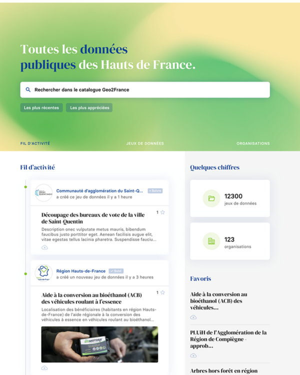
The goal is to provide a single search interface to look for any kind of public data that you have in your region. DataHub handles geospatial and non-geospatial datasets, which is a big step forward for GeoNetwork in terms of providing synergies with the Open Data world.
Following a modern approach, the DataHub targets a public audience and provides great new tools to focus more on a dataset rather than its metadata (data preview, table, map, dataviz).
Further, DataHub represents a community oriented application which is alive, offering favorites, news,as well as publisher entries. This project is a great opportunity for GeoNetwork to shine for a larger non-expert audience who just use the catalog to easily find datasets.

The latest developments are revolutionizing the services provided by GeoNetwork. The solution now has elements to meet a variety of needs, from the Open Data portal designed for the general public to the specialized professional catalog for geographic data experts.
The possibilities are vast and we are at your disposal to discuss your project ideas.
Career
Interested in working in an inspiring environment and joining our motivated and multicultural teams?


