SUEZ 3D: First version of a multi-input Cesium viewer
Pierre Laulhe
SUEZ Smart Solutions is a branch of the SUEZ Group that offers technological solutions for intelligent water and waste management. In January 2024, Suez launched a Proof of Concept (POC), a significant step in its efforts to optimize interventions on its water management network. This project focuses on exploring the possibilities offered by 3D visualization, with the main objective of providing a tool for in-depth understanding of the network and access to detailed technical information.
A creation of SUEZ Smart Solution in collaboration with Camptocamp
Suez took the initiative of entrusting the developmentof this 3D POC at Camptocamp, a decision motivated by our company's proven expertise in the use of Cesium technology. The trust placed in Camptocamp comes from more than ten years of experience in the field, making the company a pioneer whose developers are certified by Cesium. Building on previous successes, Camptocamp has established itself as a partner of choice for carrying out innovative projects based on Cesium.
The objectives of the project
A sanitation network includes pipes transporting wastewater, weirs regulating the flow, retention basins to manage overloads, lifting stations equipped with pumps, and visitable networks allowing inspection. Our project focuses on 3D modeling of pipes and installations, with a distinction between visitable networks, captured in 3D, and non-visitable networks represented theoretically.
WeWe aim to create a single interface allowing fluid navigation between two distinct modes:
- 3D outdoor encompassing all 3D objects, whatever their type,
- 3D indoor offering constrained navigation inside the conducts visitable
Synchronization between these two environments is essential, ensuring that any movement made in one mode is reflected when switching to the other.
We have at our disposal three types of objects in the following formats: GPKG (2D), IFC (3D) and OBJ (3D).
The GPKGs describe lines of the theoretical pipeline network. IFCs represent facilities related to water management, whileOBJ correspond to the visitable pipes.
The format favored by Cesium is 3D Tiles. You must therefore go through a conversion stage.
To convert the GPKGs, we developed an FME processing chain using the 2D geometries and attributes stored in the layer. We start from lines to end up with theoretical driving cylinders.
Regarding objects in IFC format, we also chose FME. The major challenge was to use the georeferencing stored in the IFC to produce the tiles.
Finally, for the conversion of meshes to OBJ format, we opted for a hybrid processing chain using a glTF conversion tool combined with the Cesium tiler.
In addition, the project offer the ability to query objects and display a window listing their attributes. Integration into a portal is also envisaged, with an API allowing communication between the portal and the application, facilitated by the use of a Web Component.
An efficient software architecture for 3D rendering and visualization
The component developed for SUEZ's 3D viewer leverages Cesium's powerful capabilities to provide an immersive 3D viewing and navigation experience.
Navigation
A notable feature of this solution is the use of Cesium's advanced features which allow navigation below from ground level, thus providing a complete and detailed representation of thenetwork underground. Constrained navigation, at the heart of the tool, is ensured by precise control of the position of the camera, with the possibility of refocusing it on specific pipes. Calculating the optimal orientation of the camera while following driving adds an additional dimension to the user experience.

In addition, in order to optimize the user experience, we have integrated a keyboard navigation option, offering an intuitive and immersive approach similar to that of video games. This feature allows users to move and navigate the 3D model with greater flexibility, ensuring an interactive and engaging experience. The addition of this keyboard navigation option enhances the usability of the viewer, providing a variety of methods to explore and interact with the 3D network, tailored to individual user preferences.

Symbology and consultation
To improve the visibility of objects, the viewer uses systematic symbology based on object attributes, in addition to specific symbology to highlight selections. On a technical level, we optimized the visibility of objects by defining a style in a language specific to the 3D viewer. Using conditional rules, we adjusted the appearance of the theoretical pipes based on criteria such as visitability, section type and associated network.
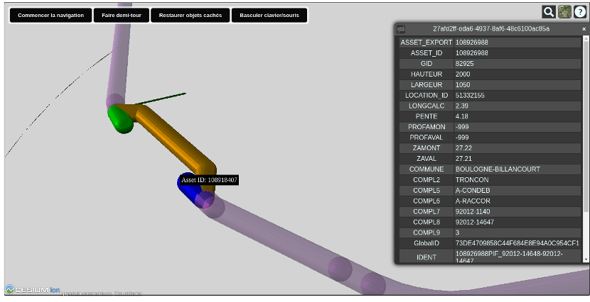
In a complex scene, where a large number of objects, even if they are close to each other, accuracy of selection can be crucial. To address this challenge, we introduced a feature to temporarily hide clicked objects, making it easier to precisely select the desired object in a dense environment. Detailed information about each object is then accessible via tooltips based on the layer's attributes.
A key aspect of the project is the seamless integration of the visualizer into the overall SUEZ solution. This is made possible thanks to the creation of a dedicated web component, guaranteeing smooth integration and harmonious use within the SUEZ ecosystem.
Camptocamp and digital twins
Camptocamp is proud to have been able to support SUEZ Smart Solution in the development of its 3D business visualizer. His work in close collaboration with the teams ofSUEZ allowed the implementation of a personalized and efficient toolbased on solid Cesium Open Source foundations.
Camptocamp’s experience with Cesium dates back more than ten years. The company is therefore among the very first companies whose developers are certified by Cesium.
This expertise allowed us, for example, to receive the Geospatial World Forum Excellence Award for the swissgeol.ch project.
This technology was also used successfully for the site schweizmobil.chFor 3D visualization of mountain hiking trails or buildings and infrastructure on the Swiss federal geoportal.
An additional example involving the use of Cesium is the digital twin project of the Rennes metropolis. This is the COOPTERR project, a territorial cooperation platform built on the basis of the digital twin of Rennes Métropole, accessible via this link.
With Cesium, 3D visualization on the web is made possible without any plugins or other additional software other than a common web browser.
Would you like to distribute your 3D data or your digital twin to your teams in a very efficient way? Give them a virtual reality experience in the context of your project? Do not hesitate to contact us to discuss your project with our expert teams in project implementation with Cesium.
Get in touch with Camptocamp
Author
Career
Interested in working in an inspiring environment and joining our motivated and multicultural teams?


