Optimizing Trail Management: Mergin Maps for Greater Annecy

Pierre Laulhe
The Communauté d'Agglomération du Grand Annecy groups together 34 communes and over 200,000 inhabitants. They share a deep connection to the mountains, a bond that is reflected in the missions of the Urban Planning and Development Department. This department is responsible for preserving and enhancing this exceptional natural environment, while ensuring the harmonious development of the territory. Grand Annecy turned to Camptocamp to find the tool best suited to their needs.
More specifically, it has to manage 682 kilometers of hiking trails, including 2,502 markers. This vast territory requires rigorous organization and the right tools to ensure effective surveying and maintenance.
This poses a number of challenges: how do you survey vast areas without 4G coverage? How to coordinate teams in the field? How can we guarantee complete, consistent and directly usable data?
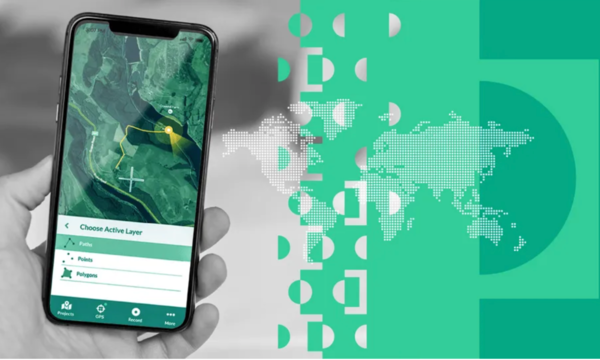
Mergin Maps is a mobile and web-based solution that enables geospatial data to be captured, stored and synchronized, even without an internet connection, for efficient management of field information.
When Camptocamp evaluated Mergin Maps, its potential was quickly recognized after in-depth testing and analysis, and we were convinced of its effectiveness, choosing to partner this solution developed by Lutra Consulting. Mergin Maps stood out as the ideal tool for the Greater Annecy project, not only for its field input capabilities, but also for its ease of use, making it immediately accessible to anyone, even without GIS skills.
Mergin Maps solutions for this mission
To fulfill this mission, we followed a classic three-step methodology: know what exists, establish a diagnosis and act accordingly. To cover such a large area, the customer divided the zone into six batches, with each team taking charge of one or more batches. Each team is responsible for making precise field entries to ensure continuous monitoring.


The Mergin Maps solution offers two approaches to managing this work: using the workpackage or displaying layers. Greater Annecy chose the second option, so as to process only one data source.
In view of the mountainous area to be covered by the teams, it is not uncommon to work in areas where access to telephone networks is impossible, hence the need to work offline. This is why we have developed the solution to overcome this problem. It was crucial to guarantee access to vector data (simple and non-bulky), backgrounds (bulky) and information already collected in PDF form (very bulky and impractical on smartphones). To achieve this, two complementary projects were associated with the main project: a PDF project and a background map project, each providing fluid access to the necessary information.
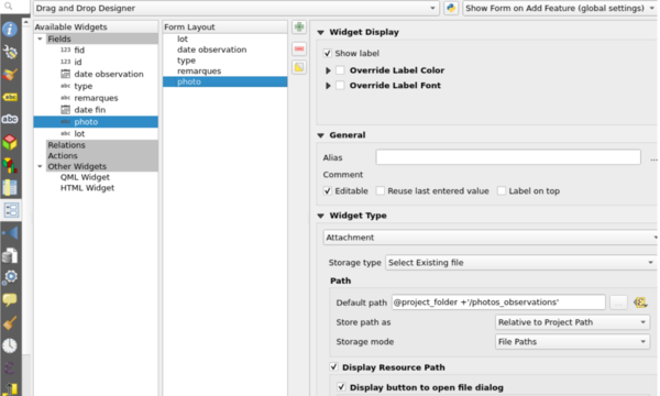
To work efficiently, we set up customized forms with automatic field calculation, input restrictions and drop-down lists, ensuring consistent input. The form included the option of taking a collection of photos for a single control point, with the option of naming them. Data synchronization had to be continuous or deferred to a single source. In this way, vector data remained the same for all users, enabling uniform consultation, updating and processing. The synchronization process was simplified to be automatic or triggered on demand.

Finally, the application had to be compatible with iOS and Android, and work with the phone's built-in GPS or an external GPS. This guaranteed maximum flexibility for teams working in the field, whatever their equipment.
Camptocamp at the service of its customers and community
The Grand Annecy project pushed the limits of Mergin Maps and contributed significantly to its improvement. As partners, we identified several areas where optimization was needed, and worked actively with Lutra Consulting to implement them.
For example, we helped improve the management of historical data. Initially, each synchronization to Mergin Cloud generated a zip file containing all the data, which could quickly become bulky and inefficient. We proposed the use of a .gitignore file type to list files to be ignored, as well as an API enhancement enabling specific versions to be deleted, thus reducing the weight of synchronizations.
We also worked on photo renaming, generating file names based on expressions derived from the data, thus offering better organization. We also tackled the problem of opening PDF documents. Currently, although it was possible to download and open documents via the form on Input, it was not possible to open a PDF already present on the phone. We therefore proposed adding functionality to open a PDF file in a PDF reader application, and would like to thank Lutra Consulting for listening to us on this issue.
Other improvements include the addition of an option to keep the GPS position in the center of the map, and the possibility of adding +/- zoom buttons. We have also reported to Lutra Consulting some difficulties encountered by users of the Grand Annecy project, notably problems with application stability when taking photos or switching applications.
The Grand Annecy project enabled Camptocamp to test and improve the capabilities of Mergin Maps for managing vast hiking territories. Thanks to technical adjustments made by our team, we overcame the challenges of field data entry, guaranteeing consistent, usable data. This project shows how the right tools can optimize the management of geospatial data, while underlining the importance of innovation and adaptability in this field.
Get in touch with Camptocamp
Author
Career
Interested in working in an inspiring environment and joining our motivated and multicultural teams?


